annual Rainfall amounts for great britain [1971-2000]
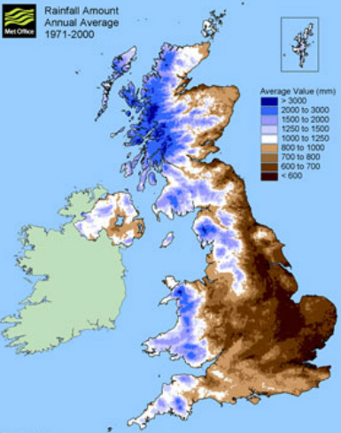
The map to the left shows the annual rainfall amounts in The United Kingdom between 1971-2000. The map shows that there is a divide between the Northern, Southern, Eastern and Western parts of the country. This divide between rainfall amounts in the western and northern parts of the country is due to warm and moist air moving into the area from Atlantic storm systems. Since they occur as frontal systems, they move west to east, seeing a reduction in rainfall as they move. Because there are a lot of mountains in the Northwestern part of the country, they help enhance rainfall, causing clouds to be too heavy to move over the mountains, preventing them from reaching the other parts of the country.
ANNUAL DAYS OF SNOW/SLEET FALLING [1971-2000]
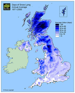
This map shows the amount of days were snow/sleet was on the ground from 1971-2000. This map is similar to the other maps due to the high elevations and moisture that moves in off Atlantic storm systems to the west of the UK.
ANNUAL DAYS of Snow/sleet falling

This map shows the average amount of days that saw snow/sleet falling from 1971-2000. Again, this map is similar to the others because of the high elevations and the moisture that moves in from Atlantic storm systems.
